مناخ فيتنام
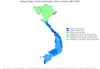
تتمتع فيتنام بمناخ متأثر بالرياح الموسمية وهو مناخ نموذجي لمناخ البر الرئيسي في جنوب شرق آسيا. [1]:25 The diverse topography, long latitude (Vietnam spans over 15° of latitude), and influences from the South China Sea lead to climatic conditions varying significantly between regions of Vietnam.[2] تشهد المنطقة الشمالية مناخًا شبه استوائيًا موسميًا ورطبًا مع أربعة فصول مميزة حيث يكون الشتاء جافًا عادةً والصيف يتراوح من الحار إلى المعتدل. [3] في المناطق الجنوبية والوسطى، يكون المناخ استوائيًا موسميًا مع موسمين فقط (مطر وجاف). [4] [5] [6] بالإضافة إلى ذلك، يوجد مناخ معتدل في المناطق الجبلية، والتي توجد في سا با ودا لات ، في حين يوجد مناخ أكثر قارية في مقاطعة لاي تشاو ومقاطعة سون لا. [4]
وفقًا لـ Indra Overland (2017)، فإن 20% من إجمالي مساحة سطح فيتنام عبارة عن منطقة ساحلية منخفضة الارتفاع، مما يجعل البلاد معرضة بشدة لتأثيرات تغير المناخ وارتفاع مستوى سطح البحر على وجه الخصوص. [7] من عام 1960 إلى عام 2011، ارتفعت الزيادات العالية بنسبة 0.24 °C و 0.28 تم العثور على درجة حرارة تبلغ °C لكل عقد في محطتي فونج تاو وكا ماو، على التوالي، الواقعتين على الساحل الجنوبي. تظهر معظم المحطات في الساحل الشمالي الأوسط زيادة قدرها 0.15 °C إلى 0.19 °م لكل عقد. من عام 2007 إلى عام 2008، تجاوزت الفيضانات في المقاطعات الوسطى مثيلتها في السنوات الثماني والأربعين الماضية؛ وواجه الجزء الشمالي من فيتنام موجة برد غير مسبوقة، استمرت لمدة 38 يومًا، مما أسفر عن خسائر في المحاصيل والثروة الحيوانية بلغت 30 مليون دولار أمريكي.
المواسم
يستمر فصل الشتاء من شهر نوفمبر حتى شهر مارس. [8] خلال فصل الشتاء، يخترق الهواء القطبي القادم من المرتفع السيبيري بعمق خطوط العرض المنخفضة، ويسهل ذلك هضبة التبت الشرقية التي تدفع الهواء جنوبًا في اتجاه الشمال الشرقي. [1]:27 At the same time, a low pressure system over Australia strengthens that generates pressure gradients that intensify cold northeasterly winds.[8] يمكن للعديد من الجبهات الباردة أن تتسلل إلى فيتنام خلال فصل الشتاء، حيث تحدث 3-4 مرات منها كل شهر في شمال فيتنام. [1]:27 This leads to cold temperatures where temperatures drop by 4 إلى 5 °م (7 إلى 9 °ف).[1]:27 Cold weather, occasionally extreme cold can persist for a long time, being characterized by a long stretch of cloudless or partly cloudy days in the first half of winter or a long stretch of cloudy and drizzly conditions in the latter half of winter.[1]:27 Cold weather occurs more frequently in the north than in the south due to cold fronts penetrating the north more frequently.[1]:27
يبدأ موسم الأمطار في أواخر أبريل/أوائل مايو ويستمر حتى أكتوبر. [9] في الصيف، يكون نمط الرياح العام عبارة عن رياح جنوبية غربية في الأجزاء الجنوبية من فيتنام ورياح جنوبية شرقية في شمال فيتنام. [10]:28 The predominantly air blocks in Vietnam are the equatorial and tropical blocks that originate from high pressure systems in the Southern Hemisphere, and a maritime tropical block originating from the subtropical high pressure system in the Pacific Ocean (Pacific subtropical high pressure).[1]:28 In addition, during summer, Vietnam is influenced by tropical air from the Bay of Bengal which occurs when a continental low pressure originating from South Asia (South Asian continental low) moves eastwards towards Vietnam, covering almost all of Vietnam and southern China; this causes hot, dry weather in the North Central Coast as westerly winds descend and warm adiabatically on the eastern slopes of the Annamite Range (Truong Son range).[1]:28 On average, 11 storms and tropical low pressures develop in the South China Sea during summer of which half are tropical cyclones that originate from the western Pacific.[1]:28 These storms and cyclones then move westwards towards Vietnam.[1]:28 On average, Vietnam is affected by 6–8 typhoons or tropical cyclones per year.[2]:25
الربيع والخريف فصول انتقالية. [10]:27 The atmospheric circulation in these seasons represent a transition between winter–summer and summer–winter respectively.[1]:28
بشكل عام، تتميز الأجزاء الشمالية من البلاد بأربعة فصول. [11] أما في الجنوب، يوجد موسمين فقط: موسم جاف وموسم ممطر. [11]
التطرفات
| البيانات المناخية لـ{{{location}}} | |||||||||||||
|---|---|---|---|---|---|---|---|---|---|---|---|---|---|
| الشهر | يناير | فبراير | مارس | أبريل | مايو | يونيو | يوليو | أغسطس | سبتمبر | أكتوبر | نوفمبر | ديسمبر | المعدل السنوي |
| [بحاجة لمصدر] | |||||||||||||
أعلى درجة حرارة سجلت على الإطلاق في فيتنام كانت 44.2 درجة.C، والتي سجلت في منطقة تونج دونج، مقاطعة نغي آن في 7 مايو 2023.
أبرد درجة حرارة سجلت في فيتنام كانت −6.1 °م (21.0 °ف) في سا با في 4 يناير 1974. أدنى مستوى قياسي عند −6.0 °م (21.2 °ف) أيضًا في هوانج لين في الأول من يناير عام 1974 والسادس من يناير عام 1974. [12] بالنسبة لدرجات حرارة الأرض، كانت أدنى درجة حرارة أرضية تم تسجيلها على الإطلاق هي −6.4 °م (20.5 °ف) في سابا في 31 ديسمبر 1975 بينما كانت أعلى درجة 74.7 °م (166.5 °ف) في بون ما ثوت في 23 مايو 1982. [1]:33 Absolute record low ground temperatures tend to be 1 إلى 2 °م (2 إلى 4 °ف) lower than record low air temperatures but absolute record high ground temperatures tend to be over 30 °م (54 °ف) higher than the air temperature.[1]:33
أعلى ضغط جوي سجل على الإطلاق في فيتنام كان في محطة لانج للأرصاد الجوية في 18 نوفمبر 1996 عندما بلغت القراءة 1,035.9 هـبا (30.59 inHg)سجلت (inHg) . [1]:29 The lowest air pressure ever recorded was at Sa Pa on 24 July 1971 with a reading of 827.0 هـبا (24.42 inHg).[1]:29
أعلى سرعة للرياح سجلت في فيتنام كانت 59 م/ث (190 قدم/ث) في كوي نون في سبتمبر 1972 على الرغم من أن سرعات الرياح تجاوزت 40 م/ث (130 قدم/ث)وقد تم تسجيل (قدم/ثانية) في دلتا الشمالية، والمناطق الساحلية لمقاطعة كوانغ نينه [1] :29
الكوارث الطبيعية
تتضمن الظواهر المناخية المتطرفة موجات الحر، والارتفاعات الباردة، والصقيع، والفيضانات، والجفاف، والعواصف الشديدة. [13]
انظر أيضا
روابط خارجية
مراجع
- 1 2 3 4 5 6 7 8 9 10 11 12 13 14 15 16 "Viet Nam Assessment Report on Climate Change (VARCC)" (PDF). Institute of Strategy and Policy on Natural Resources and Environment. ص. 31. مؤرشف من الأصل (PDF) في 2011-01-13. اطلع عليه بتاريخ 2018-11-09.
- 1 2 "Viet Nam's Second National Communication to the United Nations Framework Convention on Climate Change" (PDF). Ministry of Natural Resources and Environment. مؤرشف من الأصل (PDF) في 2018-11-09. اطلع عليه بتاريخ 2018-11-09.
- ↑ "Vietnam Climate". WorldData.info. مؤرشف من الأصل في 2025-03-30. اطلع عليه بتاريخ 2023-11-24.
- 1 2 "MỘT SỐ THÔNG TIN VỀ ĐỊA LÝ VIỆT NAM" (بالفيتنامية). Viet Nam Government Portal. Archived from the original on 2021-11-11. Retrieved 2018-11-09.
- ↑ "Vietnam". Country Nuclear Power Profiles: 2012 Edition. International Atomic Energy Agency. مؤرشف من الأصل في 2018-11-09. اطلع عليه بتاريخ 2018-11-09.
- ↑ "Climate". Vietnam National Administration of Tourism. مؤرشف من الأصل في 2018-11-09. اطلع عليه بتاريخ 2018-11-09.
- ↑ Indra Overland؛ وآخرون (نوفمبر 2017). "Impact of Climate Change on ASEAN International Affairs: Risk and Opportunity Multiplier". Norwegian Institute of International Affairs (NUPI) and Myanmar Institute of International and Strategic Studies (MISIS). مؤرشف من الأصل في 2020-07-28. اطلع عليه بتاريخ 2019-04-25.
- 1 2 Nguyen، Dang-Quang؛ Renwick، james؛ McGregor، James (2014). "Variations of surface temperature and rainfall in Vietnam from 1971 to 2010". International Journal of Climatology. ج. 34: 249–264. DOI:10.1002/joc.3684. S2CID:128597263.
- ↑ Nguyen، Dang-Quang؛ Renwick، james؛ McGregor، James (2014). "Variations of surface temperature and rainfall in Vietnam from 1971 to 2010". International Journal of Climatology. ج. 34: 249–264. DOI:10.1002/joc.3684. S2CID:128597263.Nguyen, Dang-Quang; Renwick, james; McGregor, James (2014). "Variations of surface temperature and rainfall in Vietnam from 1971 to 2010". International Journal of Climatology. 34: 249–264. doi:10.1002/joc.3684. S2CID 128597263.
- 1 2 "Viet Nam Assessment Report on Climate Change (VARCC)" (PDF). Institute of Strategy and Policy on Natural Resources and Environment. ص. 31. مؤرشف من الأصل (PDF) في 2011-01-13. اطلع عليه بتاريخ 2018-11-09."Viet Nam Assessment Report on Climate Change (VARCC)" (PDF). Institute of Strategy and Policy on Natural Resources and Environment. p. 31. Archived from the original (PDF) on 13 January 2011. Retrieved 9 November 2018.
- 1 2 "Viet Nam". Food and Agriculture Organization. مؤرشف من الأصل في 2018-12-23. اطلع عليه بتاريخ 2018-12-23.
- ↑ اكتب عنوان المرجع بين علامتي الفتح
<ref>والإغلاق</ref>للمرجعimhrecordlow - ↑ Thi-Minh-Ha Ho؛ Van-Tan Phan؛ Nhu-Quan Le؛ Quang-Trung Nguyen (2011). "Extreme climatic events over Vietnam from observational data and RegCM3 projections" (PDF). Climate Research. ج. 49 ع. 2: 87–100. DOI:10.3354/cr01021. مؤرشف من الأصل (PDF) في 2018-11-10. اطلع عليه بتاريخ 2018-11-10.