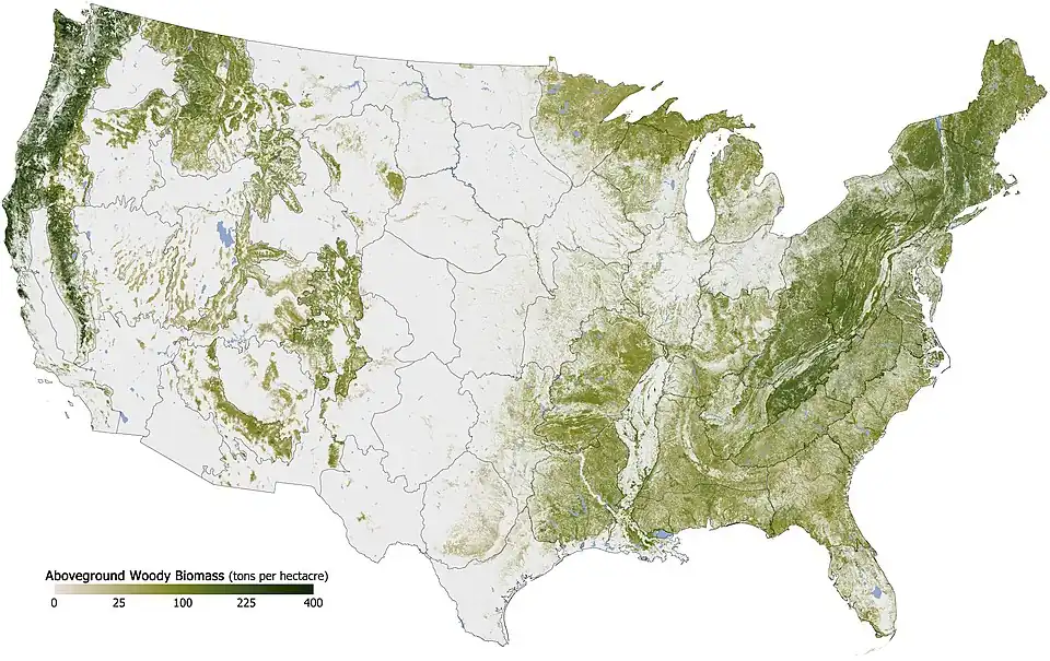
غطاء الغابات حسب الولاية والإقليم في الولايات المتحدة
قائمة حسب الولاية أو المقاطعة أو الإقليم
| الترتيب | الولاية، المقاطعة أو الإقليم |
نسبة الغابات (2016)[2] [note 1] |
|---|---|---|
| 1 |  مين مين | 89.46% |
| 2 |  نيوهامبشير نيوهامبشير | 84.32% |
| 3 |  ساموا الأمريكية ساموا الأمريكية | 80.84% |
| 4 |  جزر ماريانا الشمالية جزر ماريانا الشمالية | 80.37% |
| 5 |  فيرجينيا الغربية فيرجينيا الغربية | 79.01% |
| 6 |  فيرمونت فيرمونت | 77.811% |
| 7 |  ألاباما ألاباما | 70.57% |
| 8 |  كارولاينا الجنوبية كارولاينا الجنوبية | 68.19% |
| 9 |  جورجيا جورجيا | 67.28% |
| 10 |  مسيسيبي مسيسيبي | 65.07% |
| 11 |  فرجينيا فرجينيا | 62.93% |
| 12 |  نيويورك نيويورك | 62.88% |
| 13 |  ماساتشوستس ماساتشوستس | 60.57% |
| 14 |  كارولاينا الشمالية كارولاينا الشمالية | 59.73% |
| 15 |  بنسيلفانيا بنسيلفانيا | 58.60% |
| 16 |  جزر العذراء الأمريكية جزر العذراء الأمريكية | 57.16% |
| 17 |  أركنساس أركنساس | 56.31% |
| 18 |  بورتو ريكو بورتو ريكو | 55.62% |
| 19 |  ميشيغان ميشيغان | 55.62% |
| 20 |  كونيتيكت كونيتيكت | 55.24% |
| 21 |  رود آيلند رود آيلند | 54.38% |
| 22 |  لويزيانا لويزيانا | 53.20% |
| 23 |  تينيسي تينيسي | 52.83% |
| 24 |  غوام غوام | 52.82% |
| 25 |  واشنطن واشنطن | 52.74% |
| 26 |  فلوريدا فلوريدا | 50.68% |
| 27 |  كنتاكي كنتاكي | 49.35% |
| 28 |  ويسكونسن ويسكونسن | 48.98% |
| 29 |  أوريغون أوريغون | 48.51% |
| 30 |  هاواي هاواي | 42.53% |
| 31 |  نيوجيرسي نيوجيرسي | 41.72% |
| 32 |  أيداهو أيداهو | 40.55% |
| 33 |  ماريلند ماريلند | 39.36% |
| 34 |  تكساس تكساس | 37.33% |
| 35 |  ميزوري ميزوري | 35.16% |
| 36 |  ألاسكا ألاسكا | 35.16% |
| 37 |  يوتا يوتا | 34.48% |
| 38 |  كولورادو كولورادو | 34.42% |
| 39 |  مينيسوتا مينيسوتا | 34.08% |
| 40 |  واشنطن العاصمة واشنطن العاصمة | 33.90%[3] |
| 41 |  كاليفورنيا كاليفورنيا | 32.71% |
| 42 |  نيومكسيكو نيومكسيكو | 31.99% |
| 43 |  أوهايو أوهايو | 30.92% |
| 44 |  أوكلاهوما أوكلاهوما | 28.80% |
| 45 |  مونتانا مونتانا | 27.45% |
| 46 |  ديلاوير ديلاوير | 27.26% |
| 47 |  أريزونا أريزونا | 25.64% |
| 48 |  إنديانا إنديانا | 21.06% |
| 49 |  وايومنغ وايومنغ | 18.42% |
| 50 |  نيفادا نيفادا | 15.89% |
| 51 |  إلينوي إلينوي | 13.64% |
| 52 |  أيوا أيوا | 8.43% |
| 53 |  كنساس كنساس | 4.78% |
| 54 |  داكوتا الجنوبية داكوتا الجنوبية | 3.93% |
| 55 |  نبراسكا نبراسكا | 3.20% |
| 56 |  داكوتا الشمالية داكوتا الشمالية | 1.72% |
| — |  جزر الولايات المتحدة الصغيرة النائية جزر الولايات المتحدة الصغيرة النائية[note 2] | No data |
المراجع
- ↑ اكتب عنوان المرجع بين علامتي الفتح
<ref>والإغلاق</ref>للمرجعFIA - ↑ اكتب عنوان المرجع بين علامتي الفتح
<ref>والإغلاق</ref>للمرجعUSDA1 - ↑ Nowak, David J.; Greenfield, Eric J. (1 May 2018). "Declining urban and community tree cover in the United States". Urban Forestry & Urban Greening (بالإنجليزية). 32: 32–55. DOI:10.1016/j.ufug.2018.03.006. ISSN:1618-8667. Archived from the original on 2023-02-10. Retrieved 2022-07-25.
- ↑ "Study shows 5,000 percent increase in native trees on rat-free Palmyra Atoll". phys.org (بالإنجليزية). Archived from the original on 2023-03-11. Retrieved 2022-07-25.
- ↑ The forest percent is the percent of land that is forested (excluding bodies of water). Data for Puerto Rico, the Virgin Islands and Guam is from 2013. Data for the Northern Mariana Islands is from 2015. Data for American Samoa is from 2012. Data for the District of Columbia is from 2018.
- ↑ There is a forest on جزر بالميرا المرجانية,[4] but there is no information about what percentage of land the forest covers.
<ref> موجودة لمجموعة اسمها "note"، ولكن لم يتم العثور على وسم <references group="note"/> أو هناك وسم </ref> ناقص